The Tongariro Crossing
Finally ticked off one of my big bucket list items and I really don’t know why I haven’t done it already!
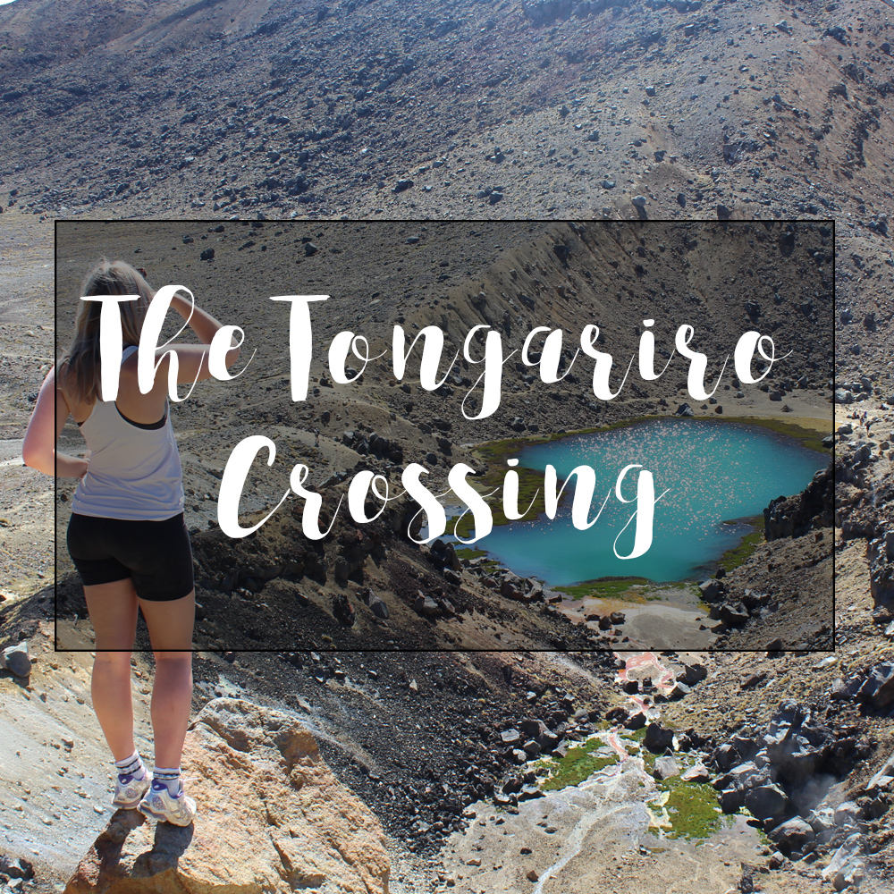
The Tongariro Crossing is a 6-8 hour walk from the base of Mt Ngauruhoe (a.k.a. Mt Doom from L.O.T.R), past a couple of craters and the Emerald Lakes, along the ridge that leads to the Mt Tongariro summit and then down to ground level at Ketetahi.

Gear
You only need a day pack with a big water bottle (at least 1 litre), some snacks, sunblock, maybe some first aid and a packed lunch. Most people wore hiking boots or sturdy sneakers (I wore my old netball shoes with long socks because I don’t own hiking boots yet) and hiking clothing/active wear. It starts off very cold so you will need a jumper, and it can be wet so a waterproof jacket is recommended.

Tip: pack a pair of jandals or sandals; once you get to the end of the walk you won’t need proper footwear and although I thoroughly enjoyed walking through the bush with bare feet, jandals would’ve been more comfortable.
It’s about a 5 hour drive from Auckland CBD and there are plenty of options for accommodation in National Park which is about 20-30 mins from either end of the walk. We drove down on Friday, stopping in Otorohanga and Taumarunui, and stayed at the charming Tongariro Crossing Lodge for Friday and Saturday night. On Saturday morning we were picked up by the shuttle van that was arranged by the lodge and driven to Mangatepopo where we started the walk at 7.30am.

They recommend everyone start at Mangatepopo and finish at Ketetahi to avoid congestion, but it also makes sense in terms of ease. From the Mangatepopo car park it’s an easy walk for the first hour or so, then it there’s a lot of winding uphill as you quickly ascend.
Ngauruhoe
Once you get to the top of the first leg, up the hill from Soda Springs, you have the option to walk to the summit of Ngauruhoe which they say takes about 3 hours to the top and back down. One of the couples from our shuttle did it and they said it took them about 1.5 hours to get to the summit and about 30 mins to get back down. There’s a path that takes you up the base of the mountain but once that finishes you basically have to just make your way up the steep face, navigating the loose rocks and shingle and keeping an eye out for ones falling on you from above. Apparently someone had to be airlifted out a few weeks ago when he was hit in the head by a falling rock. They said the view was good but the best views can be seen from the crossing. It sounds like it's a walk for the bragging rights, not the view.

From the bottom of Ngauruhoe, the walk crosses through the South Crater, then leads steeply up some rock faces, and then even more rock faces, and once you get to the high point of that section there’s the option to walk to the summit of Tongariro which is another 1.5 hours return. We didn’t do it, we stuck to the main path where we were offered incredible views of the Red Crater. Once you come over the other side of the highest point near the Red Crater you’re treated to an incredible view of the Emerald Lakes.
Emerald Lakes


There are three lakes in this area, two emerald coloured lakes and one that is more bluey. The area is very active and there are steam vents just to the side of the lakes. Getting down to the lakes is a bit of a mission, it’s all loose rocks and shingle, and you can see why they don’t recommend doing the walk in reverse; it would be a tedious walk getting back up that! The lake area smells strongly of sulfur and although I'm struggling to find it online anywhere, I'm fairly sure you're not meant to swim in them as they're unsafe and you definitely can't drink from them.

From there you press on across another crater and up to the Blue lake, which is much bigger, but not quite as striking. This lake I could find more information on and it is tapu (sacred to the local Maori) and so you cannot swim in it or eat near it. From there you have to go up hill a bit more, but for the most part that is the end of the hard slog.

It’s not long until you come out the other side of the ridge and can see Lake Rotoaira and Lake Taupo in the distance as you begin your descent. It’s a relief to get the breeze along there and the walk gets easier as it is mostly downhill back to the Ketetahi hut; a much welcomed relief at this point! From the hut to the carpark is about 2 hours if you’re on the slower side, and it does tend to go on and on, and on and on, as the landscape doesn’t change for ages. Once you finally get to the bush it’s a little steeper but lovely and cool in the shade. The path eventually runs alongside the river and you can see plenty of little waterfalls, which is always a plus for me!

I couldn’t recommend this walk enough, unless you hate walking!
For more information, you can find plenty here, or feel free to comment below if you have any questions!